Channel bottom elevations
Channel bottom elevations
Channel bottom elevations are temporary elevations in the channel. They can be managed in the submodule Channel management of the Settings module. A channel bottom elevation consists of the following elements:
- Segment: Which segment the bottom elevation applies to.
- Low/high kilometer position: The start and end points of the elevation, relative to the distance of the start of the segment and the elevation. These values cannot exceed the segment's length.
- Elevation (m): The height of the elevation with respect to the segment's nautical guaranteed depth.
- From/to date time: The period for which the elevation applies. To date time is an optional field, if no value is given the elevation applies indefinitely.
- Comment: A description of the elevation.
A new channel bottom elevation can either be added within a route, or at the Channel bottom elevations submodule. If the elevation is added at the Channel bottom elevations submodule, the position of the elevation is set with respect to the selected segment. On the contrary, if the elevation is added within a route itself, the position of the elevation is set with respect to the kilometer position of the trajectory. It is preferred to add elevations within a route, as this will handle required changes to existing elevations automatically. So, if the new elevation overlaps with a current elevation, the old elevation is automatically closed and an extra elevation is added for the remaining (non-overlapping) part of the old elevation, in addition to the proposed elevation.
Manage bottom elevations
The step-by-step plan below shows how to add a new bottom elevation for a route:
- Navigate to the Routes submodule, located within the Channel management submodule in the Settings module.
- Open the relevant route in the table.
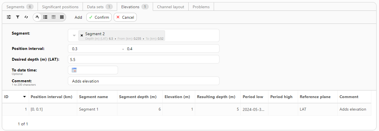
- Navigate to the tab Elevations and choose the Add action.
-
Fill in the form:
- Select the Segment to which the elevation should be applied to.
- Enter the Position interval (km) with respect to the trajectory, these values should be within the bounds of the from and to kilometer positions of the segment.
- Enter the Desired depth (m), this is the guaranteed depth of the elevation.
- The End date is an optional date/time field and can be left open. If an end date is set, the elevation is applied on the given period and automatically closed after passing the end date.
- Finally, add a description of the elevation, e.g. the reference of the elevation.
- Confirm the bottom elevation at the top of the form.

Note:
- A channel bottom elevation is added per segment. If a bottom elevation applies to multiple segments, it should be explicitly added for each segment.
- It is possible to have multiple bottom elevations per segment.
- A segment can occur in multiple routes. The entered bottom elevation on a segment is applied to each route to which the segment belongs.
- Entered bottom elevations are only visible within a route in the map component (e.g. at the Dashboard) if they are currently valid.
- In the map component a bottom elevation can be selected for further information.
- A bottom elevation can be closed within a route via the Close action. The relevant bottom elevation should be selected from the drop-down menu. Only one bottom elevation can be selected at a time. Repeat this process if several elevations must be closed.