Bathymetry
Bathymetry
The Bathymetry module is used to manage bathymetry data. A bathymetry consists of a collection of bathymetry tiles. Each tile contains the depth data for a section of a grid. A bathymetry can be applied to a route to generate more accurate depths.
Manage bathymetry data
A bathymetry can be defined in the submodule Bathymetries.
The submodule Tiles is used to manage bathymetry tiles. Tiles are added by using the Import action. The Couple to bathymetry action can be used to couple multiple tiles to a bathymetry at once.
The submodule Bathymetry-tile coupling provides an overview of which tiles are used by each bathymetry.
Input format
The Import action for bathymetry tiles expects a .zip file that contains one or multiple folders.
Folder names should start with the measurement date in a YYYYMMDD format.
Each folder should contain one or multiple files, where every file represents a tile.
The files should describe the bathymetry data in an XYZ format,
where the X and Y values are in the EPSG:25831 (UTM 31N) coordinate system and
Z values are in meters (positive values correspond to vertical measurements above ground).
Each line of the file should provide the vertical measurement for a coordinate,
with the fields being separated by three spaces.
Example:
1
2
3
4
5
6
710525.000   5926955.000   -2.691
710535.000   5926955.000   -3.011
710545.000   5926955.000   -3.301
710555.000   5926955.000   -3.620
710565.000   5926955.000   -3.850
710575.000   5926955.000   -4.110
Apply bathymetry
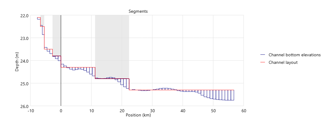
The Apply bathymetry action can be found in the Settings > Channel management > Routes module. This action uses the selected bathymetry to generate channel bottom elevations for the segments of a route:
- Each segment is divided into one or multiple subsegments, based on the configurable Maximum interval (km) value.
- A bounding box is created for each subsegment, using the width of the corresponding segment.
- An elevation is created for each subsegment based on the most restrictive depth within the bounding box.
The option Only apply restricting elevations can be used to only create an elevation when the smallest depth found in the bathymetry data is less than the segment depth.
The figure below shows an example of the created elevations when using the Apply bathymetry action on a route.
Note:
- All segments for the selected route(s) must have a width defined.
- The bathymetry data is applied to all segments that fall (partly) within one of the tiles.
- When applying a bathymetry to a route, any existing elevations of the related segments are closed.